
Not all satellite orbits are created equal.
Where a satellite flies decides what it can see, how often it sees it, and how the lighting looks.
Low Earth Orbit gives sharp, close-up snapshots.
Sun-synchronous orbits lock the local solar time so images compare cleanly.
Geostationary satellites sit high and watch a whole region without blinking.
Here’s the point: LEO, SSO, and GEO each trade off resolution, revisit rate, and coverage.
This post explains those trade-offs plainly, how they work, and how to pick the right orbit or read the data you get.
Core Overview of Earth Observation Satellite Orbits and Their Differences
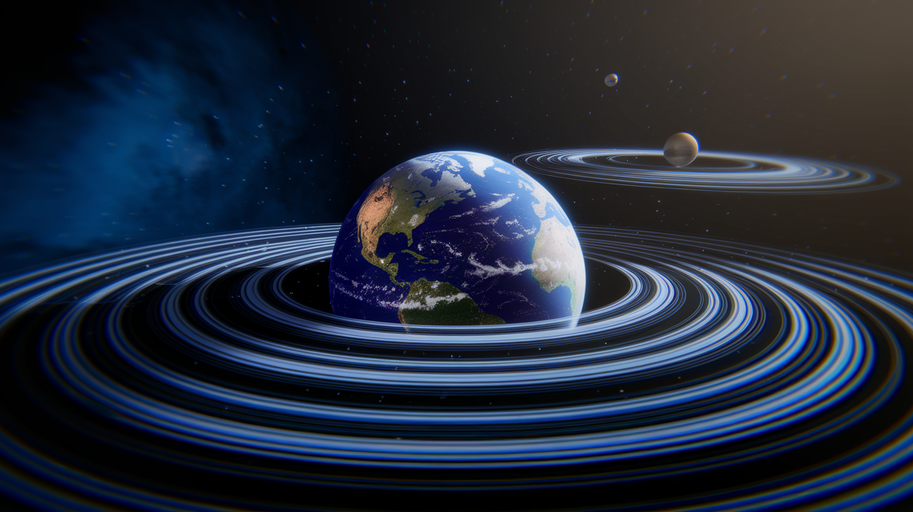
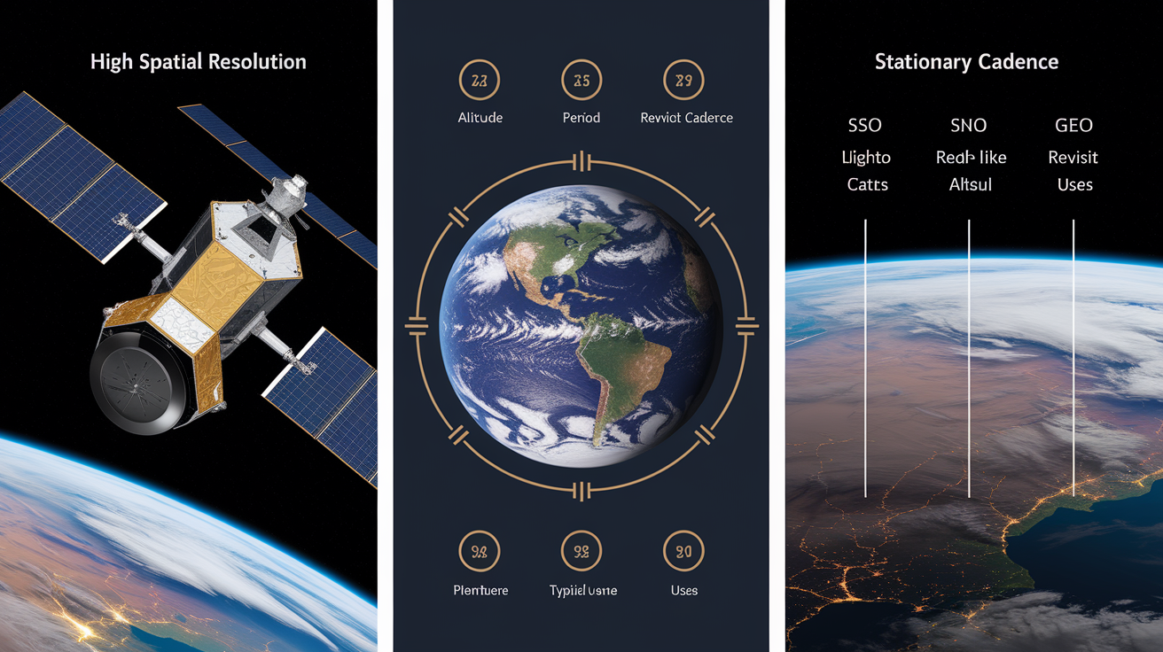
Satellites watching Earth don’t all fly the same path. The orbit you pick shapes what a satellite sees, how often it sees it, and what kind of data comes back. For Earth observation and remote sensing, three orbit families show up again and again: Low Earth Orbit (LEO), Sun-Synchronous Orbit (SSO), and Geostationary Orbit (GEO). Each one balances altitude, speed, coverage, and imaging conditions differently. If you’re trying to choose or interpret satellite data, understanding these trade-offs is where you start.
LEO satellites fly close, usually between 160 and 2,000 kilometers above Earth. They lap the planet every 90 to 120 minutes. Flying that low delivers high spatial resolution, which means sharper, more detailed images. SSO is a specialized type of LEO that holds a near-polar inclination around 97 to 99 degrees and cruises at altitudes between 600 and 800 kilometers. What makes SSO special is the orbital plane precessing at roughly one degree per day, keeping the satellite crossing any latitude at the same local solar time. That consistent lighting makes SSO the standard for optical Earth observation missions like Sentinel-2 and Landsat. GEO satellites sit much higher, exactly 35,786 kilometers above the equator, orbiting at the same rate Earth rotates. From the ground, a GEO satellite looks fixed in the sky, providing continuous coverage of roughly one-third of Earth’s surface. This persistent view works well for weather monitoring, but spatial resolution is much coarser.
Medium Earth Orbit (MEO) sits between LEO and GEO, spanning altitudes from about 2,000 to 35,786 kilometers. MEO is mostly used for navigation constellations like GPS and Galileo, though it occasionally appears in Earth observation concepts trying to balance revisit frequency and resolution. Understanding these four orbit zones helps explain why certain satellites get picked for specific tasks and why imagery from different missions looks and behaves so differently.
| Orbit | Typical Altitude | Key Advantage | Typical Use |
|---|---|---|---|
| LEO | 160–2,000 km | High spatial resolution | High-detail imaging, ISS, constellations |
| SSO | 600–800 km | Consistent local solar time | Optical EO, agriculture, land monitoring |
| GEO | 35,786 km | Continuous regional coverage | Weather monitoring, disaster watch |
| MEO | 2,000–35,786 km | Balance of coverage and latency | GPS, navigation, occasional EO concepts |
Low Earth Orbit Characteristics for Earth Observation
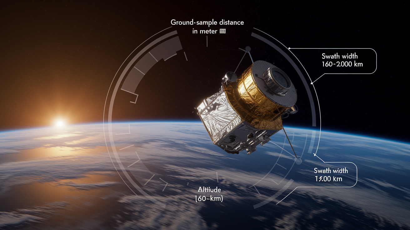
Low Earth Orbit is where most high-resolution Earth observation happens. Flying between 160 and 2,000 kilometers up, LEO satellites race around the planet every 90 to 120 minutes. Their speed balances Earth’s gravitational pull. This proximity is what gives you detailed imagery. The International Space Station operates in LEO at around 400 kilometers, and platforms like the Hubble Space Telescope sit at similar altitudes. For Earth observation, LEO’s closeness means ground sample distances measured in meters, not kilometers.
The faster a satellite moves, the more often it can cover different parts of Earth. But each pass captures only a narrow swath of ground. To get frequent global revisit, operators deploy constellations. SpaceX and Amazon are building large LEO broadband networks, and companies like Planet operate over 200 small satellites to image the entire planet daily at three-meter resolution. This combination of low altitude and multiple satellites creates powerful monitoring capabilities.
LEO advantages for Earth observation:
- Highest spatial resolution because you’re closer to Earth’s surface
- Lower launch energy compared with higher orbits, which cuts mission cost
- Fast orbital period lets you revisit frequently when constellations are deployed
- Easier access for servicing, refueling, or crewed missions
- High signal strength for both imaging sensors and downlink communications
Atmospheric drag is the major operational problem. Even the thin air at LEO altitudes slowly decays orbits, requiring regular station-keeping burns or leading to eventual reentry. The space around Earth below 1,000 kilometers is also crowded. Over 8,000 satellites currently orbit Earth, and most of them are in LEO. That raises collision risk and debris concerns. Satellites in LEO also have shorter operational lifetimes without active propulsion. The combination of high traffic density and orbital decay makes debris mitigation and end-of-life disposal critical planning steps for any LEO mission.
Sun-Synchronous Orbit Geometry and Its EO Advantages
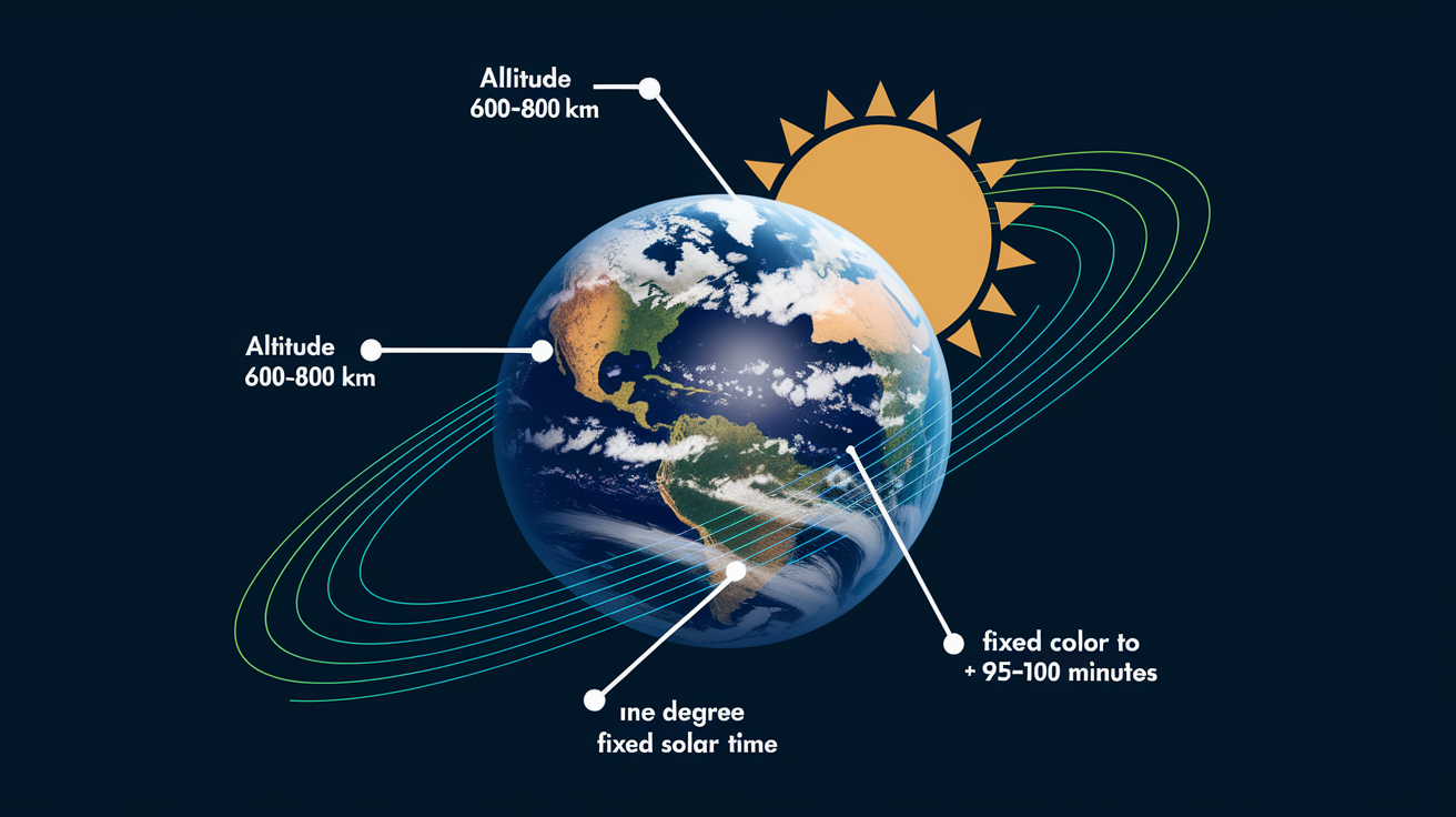
Sun-synchronous orbits are LEO orbits engineered to maintain a fixed relationship with the Sun. The orbital plane precesses eastward at about one degree per day, matching Earth’s annual journey around the Sun. This keeps the satellite crossing any given latitude at the same local solar time on every pass. Most SSO missions fly at altitudes between 600 and 800 kilometers, with inclinations between 97 and 99 degrees, completing roughly 15 orbits per day with periods around 95 to 100 minutes. The result is a near-polar ground track that gradually shifts westward, building global coverage strip by strip while keeping lighting conditions stable.
Consistent Local Solar Time
The precession mechanism locks the orbit’s orientation relative to the Sun. For instance, Sentinel-2 crosses the equator at approximately 10:30 AM local time on its descending pass, heading from north to south. Every time the satellite images a field in central France or a forest in Indonesia, the sun is at roughly the same angle in the sky. Consistent illumination removes one major variable in optical remote sensing. Shadows fall the same way. Vegetation reflects light under similar conditions. Time-series analysis becomes more reliable because lighting differences don’t confound real changes on the ground. For multispectral sensors tracking vegetation health, snow cover, or land use, this repeatability is essential. The satellite also receives continuous solar power, which simplifies energy budgets, though constant solar heating requires careful thermal management.
Pass Directions and Sensor Use
Each latitude on Earth gets crossed twice per day by an SSO satellite, once ascending (south to north) and once descending (north to south). Optical sensors typically use only the daytime descending pass to maximize illumination. Synthetic aperture radar (SAR) sensors can work day or night, so both pass directions are usable. But SAR geometry is sensitive to look direction. The radar’s incidence angle and azimuth orientation affect how features appear and how signals scatter. For change-detection applications like deformation monitoring or flood mapping, you need to match ascending imagery with ascending and descending with descending to maintain geometric consistency. Mixing pass directions introduces perspective shifts that can look like real change when they’re not.
Geostationary Orbit Coverage and Continuous Monitoring Capabilities
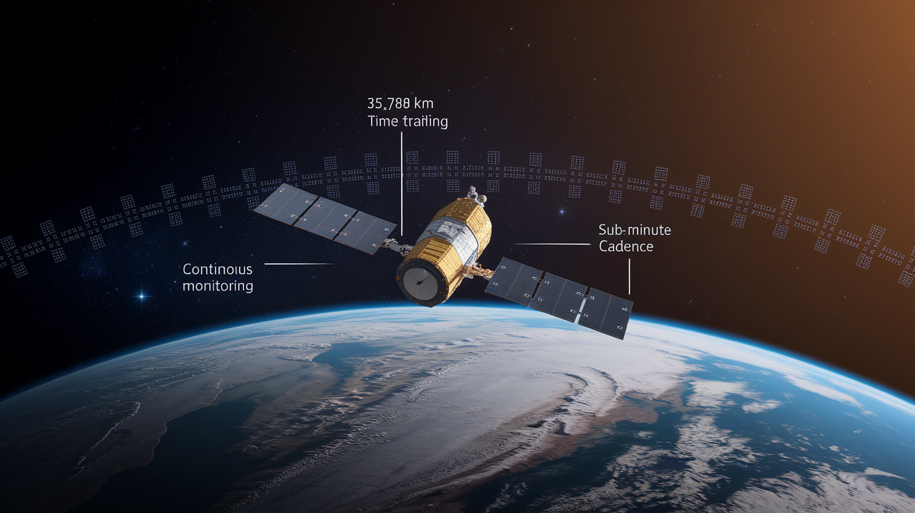
Geostationary satellites occupy a unique ring 35,786 kilometers above the equator, where orbital velocity exactly matches Earth’s rotation. To an observer on the ground, the satellite appears to hang motionless in the sky. This fixed position lets a single GEO satellite monitor roughly one-third of Earth’s surface continuously, with no gaps in coverage. Unlike LEO satellites that sweep past and disappear over the horizon in minutes, GEO platforms maintain a persistent hemispherical view, imaging the same region every few minutes around the clock.
Weather forecasting agencies operate most GEO Earth observation missions. The United States’ GOES-16, Japan’s Himawari series, and Europe’s Meteosat family all provide full-disk images of their respective hemispheres every 10 to 15 minutes. When forecasters need to track a rapidly developing storm, they can command even faster updates, capturing targeted regions every 30 seconds. This temporal cadence is unmatched. For monitoring hurricanes, volcanic ash plumes, wildfires, or severe thunderstorm outbreaks, continuous high-frequency imagery reveals evolution that snapshots from polar-orbiting satellites would miss.
GEO advantages:
- Continuous hemispheric coverage from a single satellite
- Very high temporal resolution, down to sub-minute cadence for specific regions
- No revisit gaps for time-critical monitoring
- Simplified ground-station operations, no need to track a moving satellite
The main constraint is spatial resolution. At 35,786 kilometers altitude, even large sensors can’t resolve fine detail. GOES-16’s visible channel offers approximately 500 meters per pixel at the subsatellite point, degrading to one or two kilometers toward the edges of the disk. Compare that with Sentinel-2’s ten-meter resolution from 786 kilometers. Signal latency is also noticeable. A round trip to GEO and back takes roughly 240 milliseconds, which matters for real-time interactive applications but is irrelevant for passive imaging. GEO coverage also degrades sharply at high latitudes. Polar regions appear highly foreshortened or are invisible from the equatorial vantage point, so GEO doesn’t work for Arctic or Antarctic monitoring.
Key Differences When Comparing LEO vs GEO vs SSO for EO Missions
The three orbit types solve different problems. LEO satellites fly low and fast, delivering the sharpest images but requiring constellations or accepting long revisit intervals between passes. SSO satellites are LEO platforms with carefully chosen inclinations that lock their lighting conditions, making them good for systematic optical imaging and long-term monitoring where consistent sun angles matter. GEO satellites sit high and still, trading spatial detail for uninterrupted temporal coverage of broad regions. Choosing among them means deciding whether resolution, lighting consistency, or continuous monitoring is your mission priority.
| Metric | LEO | SSO | GEO |
|---|---|---|---|
| Altitude | 160–2,000 km | 600–800 km (subset of LEO) | 35,786 km |
| Orbital Period | 90–120 minutes | 95–100 minutes (~15 orbits/day) | 24 hours (appears stationary) |
| Coverage Pattern | Narrow swath, fast ground track | Polar/near-polar, global over time | Continuous ~1/3 Earth hemisphere |
| Typical Spatial Resolution | Sub-meter to ~30 m depending on sensor | 10 m (Sentinel-2) to ~30 m (Landsat) | 500 m–2 km (GOES-16 example) |
| Revisit Cadence | Days to weeks (single sat); daily (large constellation) | 5–10 days (typical constellation) | Continuous (10–15 min full disk) |
| Example Missions | ISS, Hubble, Planet constellation | Sentinel-2, Landsat, Sentinel-1 | GOES-16, Himawari, Meteosat |
How Orbital Parameters Affect Earth-Observation Data Quality
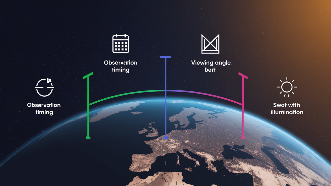
Orbit geometry controls four fundamental data characteristics: when the satellite images a location, from what angle it views the ground, how wide an area it captures per pass, and what the lighting conditions are. These factors cascade into every aspect of data usability. A high-inclination orbit provides global coverage but changes viewing angles across latitudes. A low orbit sharpens images but narrows the swath. An equatorial orbit never sees the poles. Choosing an orbit is choosing what the data will look like and what you can use it for.
Four orbit-driven factors to check when selecting imagery:
- Observation timing and revisit frequency (when and how often a location gets imaged)
- Viewing angle and incidence (the sensor’s look direction and off-nadir tilt, which affect geometric distortion and what surfaces are visible)
- Swath width (the ground area covered per pass, determining how many orbits you need for regional or global coverage)
- Illumination conditions (sun angle, shadow length, and whether imaging happens day or night)
Revisit time and repeat cycle are related but not the same thing. Repeat cycle is the number of days before a satellite returns to the same orbital ground track. Sentinel-2, for example, has a ten-day repeat cycle per satellite. Revisit time is how often a point on Earth actually gets imaged, which can be shorter because swaths overlap, especially at higher latitudes. With both Sentinel-2A and 2B operating, effective revisit drops to around five days globally. At mid-latitudes like 45 degrees north it can be two to three days due to swath overlap. For SAR missions like Sentinel-1, equatorial revisit might be six days, while polar areas get imaged more frequently because orbital tracks converge. Understanding these numbers helps you set realistic expectations for monitoring cadence and data availability. GEO satellites bypass this complexity entirely with continuous coverage, but LEO and SSO missions require careful planning to match revisit needs with available constellations and orbital geometry.
Orbit Choice Examples from Real EO Missions

Real satellite programs map cleanly onto the orbit families. Sentinel-2, Europe’s workhorse optical imaging mission, flies in sun-synchronous orbit at 786 kilometers altitude with a 10:30 AM descending node. Its ten-day repeat cycle per satellite drops to five days with the two-satellite constellation, providing systematic global land monitoring with consistent lighting. The mission was built for agriculture, forestry, and land-use tracking, all applications where repeatable sun angles and regular revisit matter more than real-time coverage.
Sentinel-1 is a synthetic aperture radar mission, also SSO. Originally, Sentinel-1A and 1B together provided six-day revisit for interferometric and change-detection applications. When Sentinel-1B suffered a power anomaly in late 2021 and was formally decommissioned in August 2022, revisit times stretched to twelve days until Sentinel-1C launched in December 2024 to restore the constellation cadence. This shows how revisit performance depends directly on the number of satellites and how losing one platform degrades coverage until a replacement arrives.
Planet operates a different model. Its constellation of more than 200 small satellites, all in LEO, delivers daily global coverage at three-meter resolution. Instead of relying on a single high-capability platform with infrequent revisit, Planet floods the orbit with many small sensors. Each individual satellite has modest capability, but the swarm achieves temporal resolution that traditional missions can’t match. This is a LEO strategy enabled by falling launch costs and miniaturized sensors.
Examples of orbit-to-mission alignment:
- Sentinel-2 (SSO): 10:30 AM local time, 10-day repeat per satellite, 5-day combined revisit, built for vegetation and land monitoring
- Sentinel-1 (SSO SAR): originally 6-day revisit with two satellites, degraded to 12 days until third satellite restored cadence in late 2024
- Planet constellation (LEO): over 200 satellites, daily global coverage, 3-meter resolution, commercial high-frequency monitoring
- GOES-16 and Himawari (GEO): continuous hemispheric weather watch, full-disk every 10 to 15 minutes, sub-minute targeted imaging
Choosing the Right Orbit for an EO Mission (Decision Criteria)

Selecting an orbit means prioritizing mission requirements and accepting trade-offs. No single orbit delivers high spatial resolution, continuous coverage, consistent lighting, and low cost at the same time. The decision process starts with identifying the most critical performance metric and then building around it.
Start by answering these questions in order:
-
Do you need the highest possible spatial resolution? If yes, choose LEO. Proximity to Earth is the only way to get sub-meter to ten-meter ground sample distances with reasonable sensor sizes.
-
Do you need consistent sun angles for optical time-series analysis? If yes, choose SSO. The precessing orbital plane locks local solar time, so vegetation indices, snow mapping, and land-cover classification stay comparable across dates.
-
Do you need continuous monitoring of a specific region with no gaps? If yes, choose GEO. Weather forecasting, disaster early warning, and real-time event tracking benefit from persistent hemispheric views and high temporal cadence.
-
Do you need daily global coverage? If yes, deploy a large LEO constellation. Single satellites in any orbit can’t revisit the entire planet daily, but distributed small-satellite networks like Planet’s can.
-
Are you monitoring polar regions or need true global coverage including high latitudes? If yes, choose SSO or polar LEO. GEO can’t see the poles, and equatorial LEO orbits miss high-latitude zones entirely.
Mission requirements dictate orbit choice, and orbit choice defines the data’s strengths and weaknesses. A Sentinel-2 image will always have ten-meter resolution and consistent morning lighting but won’t capture rapid changes within a single day. A GOES-16 image will show you a hurricane’s evolution minute by minute but can’t resolve individual buildings. A Planet constellation will cover the globe daily but at three meters, not ten centimeters. Understanding these boundaries up front means the orbit and satellite you pick actually align with what the mission needs to accomplish.
Final Words
We ran through the action: the three main orbits and the numbers that matter. LEO sits 160–2,000 km with 90–120 minute periods. SSO is around 600–800 km at 97–99° for steady local solar time. GEO is 35,786 km with a 24 hour period.
You can see the tradeoffs: detail and fast passes in LEO, consistent lighting in SSO, and nonstop regional watching from GEO.
That clear split makes picking an orbit easier. earth observation satellite orbits explained (LEO vs GEO vs SSO).
FAQ
Q: What is the difference between GEO orbit and LEO orbit?
A: The difference between GEO orbit and LEO orbit is that GEO sits at 35,786 km and stays fixed over one spot for continuous regional monitoring, while LEO (160–2,000 km) flies low for higher-resolution, faster-moving passes.
Q: What are the three types of satellite orbits?
A: The three types of satellite orbits are LEO (low Earth orbit), MEO (medium Earth orbit), and GEO (geostationary orbit); sun-synchronous orbits are a common LEO subtype used for consistent lighting.
Q: Are Starlink satellites LEO or GEO?
A: Starlink satellites are in LEO, typically around 500–600 km altitude (commonly ~550 km), giving low-latency links and fast revisits but requiring many satellites for global coverage.
Q: Is the ISS in LEO or MEO?
A: The ISS is in LEO, orbiting roughly 400 km above Earth with about a 90-minute period, which gives frequent overhead passes and easy access for crewed research.